SFU’s Institute for the Humanities announced its Fall lecture series, Democracy & Dissent, which includes my lecture on Nov.12th. I’m so honoured and excited!

(click to embiggen)
Here’s the abstract + bio:

(click to embiggen)
SFU’s Institute for the Humanities announced its Fall lecture series, Democracy & Dissent, which includes my lecture on Nov.12th. I’m so honoured and excited!
(click to embiggen)
Here’s the abstract + bio:
(click to embiggen)

(more on maps featuring sea monsters here)
Maps establish, formalize and stabilize relations between entities. They also set boundaries around human knowledge – think of how ancient maps articulated what we knew to be true and what we speculated about. So if maps solidify a set of relations that are co-extensive with human knowledge, why not extend them to include those elements that, under the spell of modernity, we have shut out of our sociotechnical imaginary?
Timothy Beatley, professor of urban and environmental planning at the University of Virginia, suggests something like this in a recent interview for Grist:
Instead maps of coastal cities that end at the shoreline, they could extend out into the waters, to show where kelp forests outside of Los Angeles are as magnificent as the redwoods outside of San Fran, or where deep-water reefs lie largely unexplored off the coast of Trondheim, Norway, or the tracts of ocean where orca whales migrate by Seattle and Vancouver.
Extending maps in this manner would have a multiplying effect on “matters of concern” (as Latour would put it), with interesting ethical effects: if it’s on a map we can no longer ignore it. In this sense new mapping practices may help restore the diagrammatic essence of maps as means to “blow apart semiotics systems or regimes of signs on the plane of consistency of a positive absolute deterritorialization” (Deleuze & Guattari, A Thousand Plateaus, p.136).
[addendum 1: as is so often the case, Google is already there with its new underwater streetview]

[addendum 2: “The shrinking of the Arctic ice sheet in the 10th edition of the National Geographic Atlas of the World is one of the most striking changes in the publication’s history”. Climate change must be real, then. But there’s more than meets the eye here since arctic ice is extremely dynamic – both between seasons (obviously) and between years. Not only is the choice of data crucial (in this case 2012, which saw historically low arctic ice levels), but the mapping itself strikes me as exercise in territorialization.]

One of the conclusions of the workshop I participated in during CHI’14 was that we needed to formulate a collective vision for the future of sustainable interaction design. Under the unwavering leadership of Six Silberman, and after a very quick turnaround, our essay was published in the Sept.-Oct. issue of Interactions, the flagship publication of the ACM’s SIGCHI.

The New York World’s Fair of 1939-1940 was by most accounts an impressive sight. Occupying 1,216 acres in Flushing Meadows, the fairgrounds were packed with exhibits, rides and stalls divided into 7 distinct zones centred around the phallic presence of the Trylon tower and the ball-shaped Perisphere. In its first year the Fair attracted an estimated 26-million visitors. Admission cost 75¢.

Unlike its predecessors, instead of focusing solely on the achievements of modern science and technology the Fair sought to illustrate a vision of the future. As the Fair’s president, Grover Whalen wrote in the brochure:
From the very beginning, we felt that the New York World’s Fair should not only celebrate a great event of the past, but should look to the future as well. The event we celebrate is, of course, the formal beginning of orderly democratic government in the United States — when million of men begin to co-operate in building their world —which is now our country.
The theme which inspires the Fair projects the spirit of this event into the future. It is a theme of building the World of Tomorrow—a world which can only be built by the interdependent co-operation of men and of nations.
Housed inside the Perisphere was Democracity: the planned city of tomorrow. It was organized “for the use of the people”, included a green belt and satellite towns for 1.5-million occupants, and was created by Henry Dreyfuss, an innovative human-centred designer that, among other things, designed the Hoover vacuum cleaner. From the pamphlet:
What we want is a great place to live in. We want to be proud of our city, not because we live in it, but because it is good to live in. Here it is…and we like it. It’s attractive and sensible at the same time. It’s pleasant because we’ve spent a lot of money to make it so…. At a low-tax rate too – because we haven’t wasted money.

As visitors sat in the revolving ring that hung over the model city, they could hear the narrator’s voice:
A brave new world built by united hands and hearts. Here brain and brawn, faith and courage are linked in high endeavor as men march on towards unity and peace. Listen! From office, farm, and factory they come with joyous song. Men working together … bound by a common faith in man … bound by their need of one another … free, independent men, knowing they can be free only because others help them to keep their freedom … independent and therefore interdependent. … Only such men and women can make the World of Tomorrow what they want it to be … a world fit for freeman to enjoy.
Democracity was designed to bring joy to its inhabitants. By cutting down working hours and the length of the commute to work, it was meant to increase its occupants’ leisure time. With buildings made of fireproof material and with transit functioning so perfectly, the police would be free to deal with “real” crime – although “The life of Democracity offers no incentive to crime.”
Oddly, it is entirely unclear how democratic Democracity is, and to what degree were its citizens involved in its design, if at all. The vision underlying it sounds like a mixture of Charles Fourier and Soviet propaganda. While the brochure makes a point that the City of Tomorrow is “Not fanciful … and not dictatorial” it also makes it clear that order is essential for its utopian ideal to materialize: “The City of Tomorrow which lies below you is as harmonious as the stars in their courses overhead—No anarchy—destroying the freedom of others—can exist here”.
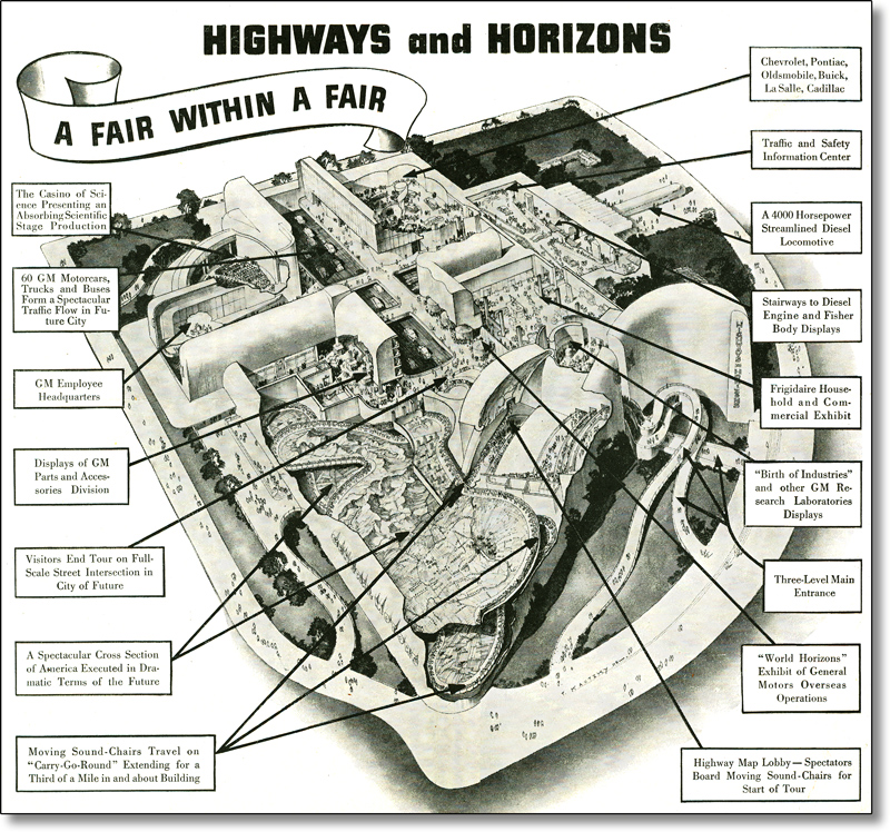
The Fair’s most popular exhibit was Futurama – a moving car ride located inside General Motor’s “Highways and Horizons” pavilion. It was created by Normal Bel Geddes, an industrial designer known for his streamlined style. Zooming up and down through the largest city model ever built, visitors would get a glimpse of the “wonder world of 1960”.
Describing the ride for The New Yorker, E.B. White wrote that it “induces approximately the same emotional response as a trip through the Cathedral of St. John the Divine”. Here’s the pavilion’s promotional film, To New Horizons.
https://www.youtube.com/watch?v=1cRoaPLvQx0
When visiting the Fair White suffered from sinusitis, spurring the following observation: “When you can’t breathe through your nose, Tomorrow seems strangely like the day before yesterday”. This may account for the sarcasm that bursts through his account of what he called a “twentieth-century bazaar”. His favourite exhibit was AT&T’s pavilion, which he describes like this:
It took the old Telephone Company to put on the best show of all. To anyone who draws a lucky number, the company grants the privilege of making a long-distance call. This call can be to any point in the United States, and the bystanders have the exquisite privilege of listening in through earphones and of laughing unashamed…. I listened for two hours and ten minutes to this show, and I’d be there this minute if I were capable of standing up.
So even the origins of Facebook can be traced to the World of Tomorrow circa 1939.
Bonus: Salvador Dali’s installation from the Fair, Dream.